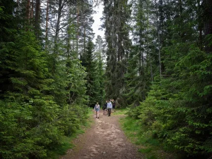
Stage 21 is the most hilly section of the Bruksleden trail, with several fairly steep ascents. The entire stretch runs through deep forests, where you have a good chance of catching a glimpse of the king of the forest.
Sub-trail Stage 21 Örtjärnen - Malingsbo
Starting Point: Örtjärnen
Ending Point: Malingsbo
Length: 14.9 km
Difficulty Level:
Time Required:
Trail Description:
You begin at the beautiful Örtjärnen, a fracture valley lake approximately four kilometers long and 50-150 m wide. The elevation differences between the lake and its surroundings are about 50 m. As you cross the bridge, you pass the border between Dalarna and Västmanland. On the southern side of the bridge, the trail splits. To the left are stages 19 and 20, heading toward Kolpen and Harplekartorp, while stage 21 branches off to the right. Along this stretch, you pass several forested ridges. After about 5 km, you reach Skälsjöarna, a great spot to take a break. Both lakes have rest areas with wind shelters. If you're lucky, you might catch a glimpse of the beautiful Great Northern Diver, which nests in the area.
The area around southern Bisen and Bastbergsåkern is picturesque with old farms and meadows. Here, you pass Malingsklack. At the top of the 317-meter-high mountain, there is a rest area where you can relax and admire the stunning view of the forests and Malingsbosjön lake.
After climbing the next elevation, Trollberget, a steep descent awaits you toward Trolltjärnen.
At Nedra Malingsbosjö, you'll find a nice swimming spot where you can pause for a refreshing dip before continuing the final kilometers to Malingsbo. The last part of the hike follows small gravel roads.
You have now reached one of Bruksleden's three endpoints. If you'd like to extend your hike, you can continue on the 45 km Malingsbo-Kloten loop.
Parking: You can park your car at the parking area between eastern and western Skälsjön or at the swimming spot by Malingsbosjön.
Public Transportation: This stage is not accessible by public transportation.
Facilities:
At Örtjärnen, where the stage starts, there are two campgrounds. Both are on the northern side of the lake. The first one has a wind shelter located in a scenic spot facing the lake. There is also a dry toilette here. A few hundred meters further along, there are two more wind shelters on a small peninsula. The location is beautiful and cozy, and there is space for several tents around the area.
At both the eastern and western Skälsjö lakes, there is a rest area at each lake equipped with a wind shelter, tables, benches, and a fire pit. The wind shelters are not intended for overnight use, and camping there is not allowed.
At Malingsklack near Bastbergsåkern, there is a scenic lookout point with benches where you can take a break.
At Nedra Malingsbosjön, you pass a swimming spot with tables and benches, a fire pit, and a dry toilette.
Visit Dalarna is not responsible for the trail or its maintenance. Keep in mind that trail conditions are affected by the seasons and weather, so it's a good idea to check the conditions before heading out on your hike.
Sub-trail Stage 21 Örtjärnen - MalingsboStarting Point: Örtjärnen
Ending Point: Malingsbo
Length: 14.9 km
Difficulty Level:Time Required:Trail Description:
You begin at the beautiful Örtjärnen, a fracture valley lake approximately four kilometers long and 50-150 m wide. The elevation differences between the lake and its surroundings are about 50 m. As you cross the bridge, you pass the border between Dalarna and Västmanland. On the southern side of the bridge, the trail splits. To the left are stages 19 and 20, heading toward Kolpen and Harplekartorp, while stage 21 branches off to the right. Along this stretch, you pass several forested ridges. After about 5 km, you reach Skälsjöarna, a great spot to take a break. Both lakes have rest areas with wind shelters. If you're lucky, you might catch a glimpse of the beautiful Great Northern Diver, which nests in the area.
The area around southern Bisen and Bastbergsåkern is picturesque with old farms and meadows. Here, you pass Malingsklack. At the top of the 317-meter-high mountain, there is a rest area where you can relax and admire the stunning view of the forests and Malingsbosjön lake.
After climbing the next elevation, Trollberget, a steep descent awaits you toward Trolltjärnen.
At Nedra Malingsbosjö, you'll find a nice swimming spot where you can pause for a refreshing dip before continuing the final kilometers to Malingsbo. The last part of the hike follows small gravel roads.
You have now reached one of Bruksleden's three endpoints. If you'd like to extend your hike, you can continue on the 45 km Malingsbo-Kloten loop.
Parking: You can park your car at the parking area between eastern and western Skälsjön or at the swimming spot by Malingsbosjön.
Public Transportation: This stage is not accessible by public transportation.
Facilities:
At Örtjärnen, where the stage starts, there are two campgrounds. Both are on the northern side of the lake. The first one has a wind shelter located in a scenic spot facing the lake. There is also a dry toilette here. A few hundred meters further along, there are two more wind shelters on a small peninsula. The location is beautiful and cozy, and there is space for several tents around the area.
At both the eastern and western Skälsjö lakes, there is a rest area at each lake equipped with a wind shelter, tables, benches, and a fire pit. The wind shelters are not intended for overnight use, and camping there is not allowed.
At Malingsklack near Bastbergsåkern, there is a scenic lookout point with benches where you can take a break.
At Nedra Malingsbosjön, you pass a swimming spot with tables and benches, a fire pit, and a dry toilette.
Visit Dalarna is not responsible for the trail or its maintenance. Keep in mind that trail conditions are affected by the seasons and weather, so it's a good idea to check the conditions before heading out on your hike.